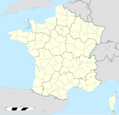
Saint-Epvre
Saint-Epvre (daitsch: St. Erffert, 1940-1944: Apern) ìsch e franzesische Gemää im Département Moselle in de Rechion Grand Est (bis 2015 Rechion Lothringe).
| Saint-Epvre | |
|---|---|
|
| |
 | |
 | |
| Verwaltung | |
| Land |
|
| Region |
|
| Département | Moselle (57) |
| Arrondissement | Sarrebourg |
| Kanton | Le Saulnois |
| Kommunalverband | Saulnois |
| Maire | Jean-Pierre Leonard (2014-2020)[1] |
| Code Insee |
57609 |
| Boschtlaitzahl |
57580 |
| Aiwohner | |
| Aiwohner | 174 |
| Flech | 4,67 km2 |
| Bevelkerungsdicht | 33,83 Iiw./km2 |
| Lach | |
| Koordinate | 48° 58′ 26″ N, 6° 26′ 14″ E / 48.973888888889°N,6.4372222222222°EKoordinate: 48° 58′ 26″ N, 6° 26′ 14″ E / 48.973888888889°N,6.4372222222222°E |
| Hech | 232 m |
D Gemää gheat zum Kanton Le Saulnois im Arrondissement Sarrebourg.
Verwaltung Schaffe
De Maire vun Saint-Epvre isch de Jean-Pierre Leonard. Saint-Epvre gheat zum Kommunalvaband Saulnois.
Bevelkerungsentwicklung Schaffe
| Johr | 1968 | 1975 | 1982 | 1990 | 1999 | 2008 | 2013 |
| Aiwohner | 165 | 161 | 152 | 161 | 141 | 160 | 167 |
Dialekt Schaffe
De draditionell Dialekt (Patois) vun Saint-Epvre gheat zum Lorrain.
Fußnote Schaffe
- ↑ (franzesisch) Liste des maires au 25 avril 2014 (data.gouv.fr)
Ajoncourt | Alaincourt-la-Côte | Aulnois-sur-Seille | Bacourt | Baudrecourt (Moselle) | Bréhain | Château-Bréhain | Chenois | Chicourt | Craincourt | Delme (Moselle) | Donjeux (Moselle) | Fonteny (Moselle) | Fossieux | Frémery | Hannocourt | Jallaucourt | Juville | Laneuveville-en-Saulnois | Lemoncourt | Lesse (Moselle) | Liocourt | Lucy (Moselle) | Malaucourt-sur-Seille | Marthille | Morville-sur-Nied | Oriocourt | Oron | Prévocourt | Puzieux (Moselle) | Saint-Epvre | Tincry | Villers-sur-Nied | Viviers (Moselle) | Xocourt
